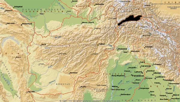
The Wakhan is a narrow panhandle of valleys and high mountains that stretches eastward from the province of Badakhshan in northeastern Afghanistan following the head waters of the Amu Daria to its sources in the Pamir mountains. It borders Tajikistan to the north, Pakistan to the south, and China to the east. Between Eshkashem and the easternmost point of Afghanistan, the distance is approximately 350 km. The corridor is widest (65 km) in the middle, where it includes the Nicholas Range; it is narrowest along its western third, where the width is 13-25 km except for a breadth of 30 km at the headwaters of the north-flowing Ishtragh River. At the western entrance, the corridor is 18 km wide.
The Wakhan was established as an imperial buffer zone between the Russian and British empires in the late 19th century. The Wakhan and Pamir are an area of unique interest both from the point of view of its natural environment and biodiversity as well as its human population of settled Wakhi farmers and transhumance herders, the yurt-dwelling Kirghiz.
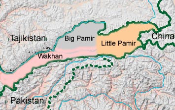
The Wakhan is divided into three geographical sections: the main Wakhan strip between Eshkashem and Sarhad-e-Boroghil, and the Pamir Knot, which is made up of two blocks of high mountains: the Pamir-e-Kalan or Big Pamir; and the Pamir-e-Khord or Little Pamir.
The main Wakhan is comprised of a narrow strip of riverine terrace along the left bank of the Panj River, flanked to the south by the easternmost spurs of the Hindu Kush mountains and crossed by many stony fans and flood washes issuing from these ranges. It is about 180 km long from east to west (Eshkashem to Sarhad-e-Boroghil, including 110 km for the Wakhan Corridor, Eshkashem to Qala-e-Panj) and seldom more than about 20 km broad between the Tajikistan and Pakistan frontiers in the Corridor.
The mountains, which form an almost impassable barrier along the southern frontier, rise to snow-covered peaks and ridges of 6 000 meters and above, with glaciers and deep, steep, rocky valleys, which occasionally give access through to Chitral on the Pakistan side. These valleys are used as summer grazing for livestock belonging to the villagers living along the line of the river, and are also home to mountain ungulates such as ibex and urial and their main predators, the snow leopard and wolf. Red fox, lynx, various small wildcats, and martens also occur here as well as their prey, the cape hare, marmots, pikas and a variety of small rodents voles and mice.
This area is inhabited by Wakhi-speaking farmers cultivating heat, barley, pulses, and a little millet and potatoes. Barley becomes the main-indeed the sole-crop in the middle-altitude aylaq (summer camp) between 3 400 and 3 600 m. Wheat is the dominant cereal crop up to 3 400 m. with barley above this altitude.
The Wakhan River flows through this stretch of highly glaciated valley in an ever-changing bed characterized by vast and spectacular expanses of gravel flats and stony washes. The mountains on either side rise for the most part rather precipitously until reaching Sarhad, which lies at the end of a broad basin where the river enters from the Little Pamir out of a series of deep gorges. The broad Boroghil Valley enters here from the south, leading up and over the Boroghil Pass (3 798 m) to Chitral. This was the pass that haunted the late 19th century Imperial Britons as being the one through which they feared the Imperial Russian Cossacks, equipped with cavalry and artillery, would come on their way to invade India. It is the only pass in this area where this would have been possible and which was a compelling strategic consideration for British control of Chitral.
The Big Pamir
The Big Pamir comprises the main block of mountains North of the Wakhan Valley of about 4 500 km2, about 100 km from east to west and between 20 and 60 km broad from north to south. It includes the Lake Zor Kol (or Lake Victoria) that marks the border with Tajikistan. It is 20 km long and 2-5 km wide.
This is home to the Marco Polo sheep, as well as ibex, urial, snow leopard, brown bear, lynx, wolf, and fox, the long tailed marmot (Marmota caudata), various wildcats, martens, weasels, otters, hares, pikas and small rodents. The highest ranges rise to between 6 700 and 6 900 m and are characterized by perpetual snow and glaciers from which streams drain north into the Amu Daria and south into the Wakhan River. There are indications that the glaciers have been retreating at a rather rapid rate in recent years.
The northwestern and southern slopes of these valleys provide grazing for transhumance Wakhi herding families with settled homes in the villages along the Wakhan Valley between Qala-e-Panj eastwards to Sarhad-e-Boroghil. The northeastern section of the Big Pamir Mountains is inhabited by yurt-dwelling Turkic Kyrghyz herding families, living all year in their felt yurts; tending their flocks of sheep and goats as well as cattle, yaks, horses, and Bactrian camels; and moving seasonally over the mountain range, although inevitably and seriously restricted by the international frontiers and the recent political events in Afghanistan.
The main mountain grazing slopes up to over 4 000 m are dominated by perennial species such as Artemisia, Astragalus, Ephedra, Cousinia, and Oryzopsis, with grasses such as Stipa and ephemerals such as Poa. The famed Marco Polo 'sedge meadows' or rather 'sedge pastures' on the higher valley flats are dominated by Carex, Kobresia, and fescues (Festuca spp.). The slopes above 4 800 m have a rich alpine flora including Thymus, Saxafraga, Aster, Potentilla, Pedicularis, Primula, and others.
The Little Pamir
The Little Pamir consists of two main mountain ranges at the eastern end of the Pamir Knot, divided by the Waghjir Valley. The area lies upstream and east of Sarhad-e-Boroghil and to the south of the upper Wakhan River, bordering on Pakistan (Hunza and Gilgit) and the Karakoram Valleys to the south, Tajikistan to the North and China (Xinjiang-Uigur Autonomous Region) to the east. It comprises a high mountainous area with ridges and peaks rising to between 6 500 and 7 000 m, the highest peaks being those along the short Afghan frontier with China.
The Little Pamir is divided into two halves east and west by the Waghjir Valley and Pass (4 923 m) that gives access to China. Another high pass, the Tegerman Su Pass (4 872 m), leads into China with access to the ancient Silk Road cities of Tash Gorgan and Kashgar. On the northern border, east of Zor Kul Lake the frontier with Tajikistan is marked by a range of glacier-filled mountains, high plateaux, and alpine lakes, which is in effect an extension of the Big Pamir range. Although the western end of the Little Pamir is used to some extent by transhumance Wakhi herders from Sarhad and upper Wakhan for seasonal grazing, the Little Pamir is mainly the home of the yurt-dwelling, Turkic-speaking Kyrghyz and their herds. The Kyrghyz share the Little Pamir with a population of Marco Polo sheep, ibex, and other wild animals.
The Little Pamir includes the famous Lake Chaqmaqtin. The area was first explored by Marco Polo and was subsequently used as a gateway to China on the Silk Road. The Little Pamir has been commonly referred as "the roof of the world". According to Sir Lord Curzon, it includes the source of the Oxus (Amu Daria River).
Borders
Travelers in the Wakhan can never be unconscious of frontiers, either with Tajikistan to the north or with Pakistan to the south, as they are always within sight, either along the river or along the mountain ridges. There are a number of places along the main Wakhan Corridor between Eshkashem and Qala-e-Panj and further on alongside the Amu Daria until Lake Zor Kol where it is quite easy to throw a stone across the river to the occasional asphalt road running along the Tajikistan side.
The northern boundary with Tajikistan is formed by the Amu Daria river, which is also known as the Panj or the Oxus. Occasional bridges across the river to the north, at Eshkashem at the western end of the Wakhan and at Ghaz Khan, just upstream of the Amu Daria/Wakhan river confluence, are currently guarded by Russian and Tajik frontier guards, who are known to shoot those who try to cross unauthorized. There are other possible transfrontier crossing points at Zor Kol Lake and at the far eastern end of the northern frontier (Ghund Jo Boi), where part of the border has been fenced by the Russians. These crossing points are closely guarded and closed, although it is possible to cross the bridge at Eshkeshem for those who possess the correct papers and visas. In September 2002 a new bridge was completed 40 kilometres downstream of Eshkashem, between Korokh in Tajikistan and Sheghnan in Afghanistan. Other crossing points are proposed under the Aga Khan's programme and are under discussion.
The southern frontier with Pakistan runs along the ridge and watershed of the mountains, which make the easternmost spurs of the Hindu Kush range until they merge in a jumble of high mountains and glaciers where the Pamir and the Karakoram ranges meet on the borders of China, Afghanistan, and Pakistan.
The border with China is closed and strictly off-limit to any civilian. The Chinese side of the Afghanistan-China border is a military zone and it is not a good idea to venture anywhere beyond the Waghjir Pass or the Tegerman Su Pass. According to the Institute of Peace & Conflict Studies, officials in Beijing have admitted that trafficking is taking place in Wakhan and fear that the profits are going to fund Uighur separatists in Xinjiang.
Crossing borders illegally is not recommended for three reasons:
- It is risky for you, as you are likely to be suspected of spying, terrorism or smuggling and remain in custody for a period of time
- It may be damaging for locals as border disputes mechanically reduce their chance to see the border that they so badly need become officially open one day
- Border disputes are also likely to create diplomatic tensions between the two countries, which may prompt authorities to further restrict the area to foreigners.
If you really want to cross an officially closed international border, you need to get permit from the two countries to get through.