See road map here.
There are several options to travel between the Big Pamir and Wakhan in either direction. A river route that goes along the Amu Daria from Bitebet all the way to Ghaz Khan. A high route that stays away from the Amu Daria and that crosses another high pass before coming out in the Wakhan Valley in either Ouezet or Sargaz. Coming from Zor Kol the river route is certainly physically less difficult and more straightforward than the high route. However, there is nobody living on the river route between Elghonok and Ghaz Khan while there are many settlements (both Wakhi and Kirghiz) on the high route. While the high route may therefore be more culturally interesting, the river route, especially between Ali Su and Ghaz Khan, is really beautiful. Note that it is possible to walk up and down most valleys (Shikarga, Ali Su, Bitebet...) and therefore alternate walking on the high and the river routes.
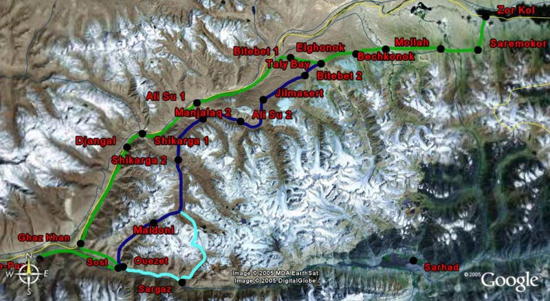
Zor Kol to Qala-e-Panj (via Ghaz Khan) (green route)
After a couple of hours walking westwards from Saremokor, you will get to the settlement of Mollah. There are actually two settlements that have that name, separated by one-hour walking distance. From Mollah to Bechkonok, it is a 3-hour hike. Less than two hours later is the Elghonok Valley where Buzkashi games are occasionally organized. You may overnight in either Bechkonok (its leader is Mohamad Aslam Khan) or Elghonok (Fazel Shah). An excellent guide in Bechkonok is Abdul Rafar Isabek.
Elghonok is the last settlement on the river route before Ghaz Khan. It takes a minimum of 3 days to cover the route between Elghonok and Ghaz Khan. Beyond Elghonok, the route goes down to the Amu Daria at Bitebet Valley via Taly Bay Valley. Then come the valleys of Ali Su, Manjalaq and Shikarga. There are many herder's shelters all along the way so it is never a problem to find a place to overnight. Between Shikarga and Ghaz Khan, the route goes via Djangal and the scenery is absolutely fantastic. Both Shikarga and Djangal are beautiful places to overnight.
In Ghaz Khan, it is possible to stay at the house of Walijan, the local Shah. From Ghaz Khan, the road does not continue westwards towards Qala-e-Panj as expected but goes back westwards on the right bank of the Wakhan river until Sost bridge. Allow a full day to cover the journey between Ghaz Khan and Qala-e-Panj. Overall, it takes 5 days to walk between Saremokor and Qala-e-Panj via Ghaz Khan.
Zor Kol to Qala-e-Panj (via Ouezet) (dark blue route)
An alternative is to stay uphill westwards of Taly Bay through the valleys of Taly Bay, Jilmasert, Ali Su, Manjalaq and Shikarga (some, but not all, are inhabited). In Shikarga, the route goes southwards to the Wakhi village of Ouezet on the right bank of the Wakhan river via Kund Thur. There are at least three passes between Ouezet and Shikarga, ranging from 4 350 m to 4 500 m. It takes around 2 days to walk between Shikarga and Ouezet. Allow another half-day to get to Qala-e-Panj. Overall, it takes 5 days to walk between Saremokor and Qala-e-Panj via Ouezet.
Zor Kol to Qala-e-Panj (via Sargaz) (light blue route)
There is another route going strictly southwards from Shikarga that comes out in the Wakhan near Sargaz. Although this route seems to be used, the satellite imagery suggests that it goes through large glaciers. The route seems to be going via a place called Sareaz.
See road map here.